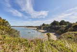
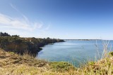
Paysages sauvages
 Itinéraire Vélo de ville
 Départ : Férel
 Arrivée : Pen Bé - Assérac

 ITINERAIRE_DEPART_ARRIVEE
 ITINERAIRE_POINT_INTERETS
Circuit n° 1
- Praktische Informationen :
") Durée (à vélo) 1h05 ou 1h55
Durée (à vélo) 1h05 ou 1h55 Länge: 13.2 km ou 23.8 km
 Abfahrts-Ort Férel
 Ankunfts-Ort Pen Bé - Assérac
 Zugang: Place de la Mairie - Férel
 Strecke markiert in Balises vélo
Download
- PDF_Topoguide VELO Les Belles échappées_Fiche n°3_Paysages sauvages - Férel_Herbignac_Assérac (6.79 Mo)
- PDF_Radtour - Natur pur (2.04 Mo)
- GPX_Fiche n°3_Paysages sauvages (206.59 Ko)
- PDF_Cycling Topoguide Beautiful Escape_File n°3_wild landscapes (61.26 Mo)
- PDF_Radfahren Topoguide Schone Wanderausfluge_Datei nr3_Wilde landschaften (61.26 Mo)